TRACEABLE REASONING · ZERO HALLUCINATION

The connectable data center land, identified before everyone else.

Grid connection is the first bottleneck of a data center project — but not the only one. DataScoot cross-references HV grid capacity, land, ZAN, water, fiber and acceptability across an entire territory, then delivers a short-list of connectable sites, scored and justified source by source.

94M land parcels. Custom filtering criteria
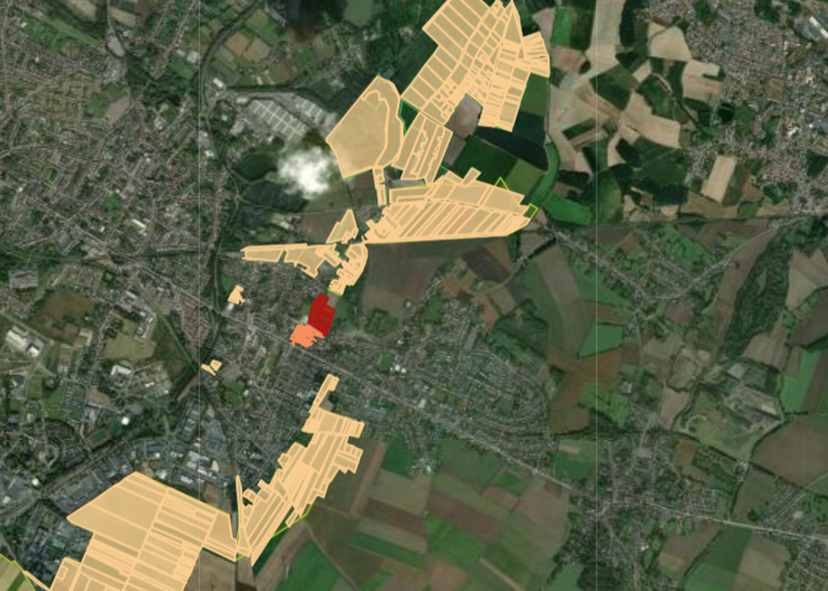
Valenciennes–Denain–Escaudain corridor (59)Colocation 1–20 MWData center land qualification · Nord (59)

Data center land qualification · Nord (59)

Cartofriches brownfields + compatible economic zones

2 594
Universe analyzed574 brownfields + 2,020 economic zones
87
Operational sub-poolSelected by DC relevance · −2,507
68
Scored shortlistAfter risk + zoning filters · −19
38
Green sites ≥ 70/100Ready for review · −30
5
Corridor top sitesValenciennes–Denain · 92.5–95/100 · −33
5 top sites out of 2,594 land parcels · strong HV grid connection, ZAN-compatible, waste heat outlet < 5 km

Use cases

One question : where to build, and under what conditions?

Whether you're looking for a single site that can connect quickly or comparing a portfolio at country scale, DataScoot adapts its qualification engine to data centers.

Connectable sites: clearing the grid bottleneck

Grid connection conditions everything: a new RTE line can take 5 to 7 years. DataScoot measures proximity to substations (225–400 kV), identifies power corridors and France 2030 turnkey sites, and ranks land where capacity is already available. It's the only way to hold a realistic time-to-power.

Livrable
HV substation proximityPower corridorsFast-track sites
Common foundation · cross-cutting

We start from a region, we end with a connectable, ready-to-review site.

For each candidate parcel, DataScoot gathers every multi-source constraint: HV grid connection capacity, zoning (warehouse-compatible), risks (flood, soil shrink, technological, mining), ZAN, water resources and waste heat outlet (ERF obligation), fiber/IXP connectivity and institutional acceptability. This foundation produces traceable reasoning: retained sites are justified source by source, and so are the discarded ones.

Detailed parcel fileConstraints mapPotential qualification

The power is there. So is the land. What's missing is the tool to bring them together before everyone else.

Typologies

Three data center scales, three land grids.

Project size changes everything: footprint, power capacity, connectivity priority. DataScoot adjusts the weighting to your implementation profile.

Edge · periphery

Edge / micro-DC

100 kW – 5 MW · a few hundred to a few thousand m²

A mesh of small sites close to users: local caching, IoT, 5G, low latency. Here, everything hinges on urban integration and proximity to a fiber POP.

Key criterion : connectivity & urban integration
Acoustic constraint, distance to local POP
Regional colocation

Regional DC

1 – 20 MW · 1 to 3 ha · existing buildings preferred

Multi-tenant in a business park, balancing latency and available land. Warehouse zoning designation, HV delivery substation, buffer from residential areas.

Key criterion : power / fiber / land balance
This is the target of the Nord (59) report
Hyperscale campus

Hyperscale / AI

&gt; 40 MW, often &gt; 100 MW · 10 to 50 ha

Multi-building campus backed by an HV line and a substation with high residual capacity. Escaudain targets 700 MW on RTE fast-track for the Data4 campus.

Key criterion : HV capacity & land reserve
Power score weighted at 50% in this variant

Scoring method

One score, seven dimensions, one risk gate.Example · adaptable grid

The grid below is an example: weightings, dimensions and thresholds are indicative. Natural and climate risks are first treated as an eliminatory filter: a site in a no-build zone is discarded before any scoring. Remaining sites are then rated out of 100 using an explicit weighted grid. You can audit every weight and every source.

Overall score = 30% × power + 15% × connectivity + 15% × ERF + 15% × zoning + 10% × ZAN + 10% × water + 5% × acceptability
Natural & climate risks
Upstream
Eliminatory filterSoil shrink-swell (RGA), flooding (PPRI / TRI), seismicity (Eurocode 8), mining risk (PPRM), technological risk (PPRT / Seveso), cross-referenced via the Géorisques API. No-build zones are ruled out before scoring.
Power
30%
Proximity to an HV substation (< 3 km = strong) and power corridor. The #1 factor.
Connectivity
15%
Proximity to IXP/POP, multi-carrier high-speed fiber, dark fiber potential.
ERF · waste heat
15%
Thermal outlet (district heating network) < 5 km, legal obligation since 2026 for DCs ≥ 1 MW.
Zoning (PLU)
15%
Zoning compatible with 'warehouse' land use (U / AU economic-purpose zones).
ZAN
10%
Already artificialized land (brownfield, industrial zone, built), usable under ZAN constraints.
Water
10%
Navigable waterway < 2 km (cooling); penalty for water-stressed SDAGE zones.
Acceptability
5%
Local authority position, SRADDET/SCoT, history of local disputes.
This risk gate, combined with regulatory compatibility (zoning, pipelines, ICPE), rules out disqualifying sites upstream. On the Nord case: 19 sites eliminated out of 87 before scoring.

This grid fully adapts to your criteria

The example above reflects a data center case, but nothing is fixed. You freely define the dimensions used, their weightings, the eliminatory thresholds and the sources mobilized — we align the method with your priorities and your investment doctrine, not the other way around.

Deliverables

Deliverables ready for the committee.

Every engagement produces a structured, exportable deliverable linked to primary sources. Scoring assumptions are documented and the code is reproducible.

01

Structured PDF report

Executive summary, selection funnel, per-site sheets with per-dimension score, per-criterion verdicts and fully cited sources.

02

Excel shortlist + GeoPackage

Multi-tab workbook (ranked shortlist, Top 10, methodology) color-coded green/orange/red, and CSV / GeoPackage files ready to load into your GIS.

03

Committee brief + Python code

A ranked recommendation note for the investment committee, plus the auditable analysis code, reusable in your stack.

A study that keeps watching over your territory

Activate monitoring: DataScoot watches official sources. As soon as a turnkey site is designated, a zoning procedure advances, a substation is upgraded, or a competing project emerges on your corridor, you're alerted.

Monitoring

For whom

Built for those who qualify a site before committing capital or a client.

An upstream institutional qualification layer that compresses the pre-due-diligence phase from several weeks to a few hours.

Specialized DC brokers

CBRE Data Center Solutions, JLL Data Centers, Savills, BNP Paribas Real Estate: feed your pipeline with justified 'power & fiber ready' sites, and present your hyperscale clients with an already defensible short-list, ready for decision-making.

"Which connectable sites can I propose to a hyperscale client on this corridor, starting this week?"

DC developers & operators

Data4, OVHcloud, Yondr, hyperscalers and infrastructure funds: build a territorial longlist in a few days, de-risk your time-to-power and cost assumptions, and focus your Site Development teams on sites that are actually connectable.

"Which brownfields on the corridor combine HV capacity, warehouse zoning and ZAN compatibility?"

Local authorities & investment agencies

EPCIs, metro authorities, regional agencies (Hauts-de-France Invest, ADIRA…): objectively assess your territory's data center potential, identify usable brownfields, and present investors with a sourced land file, ready for Choose France.

"Which of our business parks and brownfields can we position as turnkey DC sites?"
Built exclusively on official public sources

CartofrichesGéoportail de l'UrbanismeGéorisquesRTEARCEPFrance Chaleur UrbaineDVFCadastredata.gouv.fr

Why DataScoot

Why DataScoot versus a broker, an LLM or your internal GIS.

Every tool has its use. DataScoot is the only one built to turn public data into a scored, auditable data center site short-list, ready for decision-making.

CriterionDC broker / advisorCBRE, JLL…LLMs & chatbotsChatGPT, Gemini…In-house GIS / dataQGIS, data team…DataScoot
Covers every relevant analysis angle✓✗✗✓
On-demand cross-referencing of grid + zoning + risks + ZAN + water + fiber✗✗✓✓
Auditable multi-criteria scoring, Python code delivered✗✗✓✓
Zero hallucination: every figure sourced✓✗✓✓
Written report ready to decide✓✗✗✓
No data team or 6-week consultancy required✗✓✗✓
Profile-based variants(Edge / colocation / hyperscale)✗✗✗✓
Query & data confidentiality✓✗✓✓

Proof by example

Test DataScoot on your territory.

We scope a perimeter and a DC typology together, then produce a sourced short-list. You judge DataScoot on a concrete result, on your own corridor.

A targeted sample on a scope we define together: a real preview of the deliverable, on your sector.

  • Complete land inventory: brownfields, turnkey sites, compatible economic zones
  • Mapped proximity to HV substations and power corridors
  • Risk filtering (flood, soil shrink, technological, mining) and PLU / ZAN / ERF regulatory compatibility
  • Scored shortlist & usable Excel file
  • Reusable and auditable Python code included

Frequently asked questions

No, and we say so clearly in every report. The actual residual capacity of RTE and Enedis substations isn't available as open data: our indicator measures geographic proximity to an HV substation, which is a necessary condition but not a guarantee. A formal connection study with RTE/Enedis remains essential before any commitment. What we do rule out upstream are all sites that aren't geographically connectable.

No. It's an upstream qualification layer: it ranks the pool and rules out dead ends (incompatible zoning, mining risk, high flood risk) so you engage due diligence (soil studies, grid connection, negotiation) only on the right sites. Brokers and consultancies then step in, better targeted and faster.

The scoring rewards already-artificialized land (brownfields, industrial zones, existing buildings) and penalizes agricultural or natural land. This is consistent with ZAN doctrine and with operators' actual strategy, who favor already-connected brownfields (Escaudain, former Usinor; Nozay, former Nokia). We cross-reference Cartofriches, prior industrial activity and decontamination status.

Yes. The same site base is re-weighted by profile. An Edge DC values connectivity and urban integration; a hyperscale heavily values power capacity (up to 50% of the score) and contiguous land reserve. On the Nord case, the Edge variant moves up sites in the Lille metro area, while the Hyperscale variant puts Escaudain in first place.

Exclusively official public sources: Cartofriches (Cerema), France 2030 turnkey sites (ANCT), Géoportail de l'Urbanisme (zoning, easements), Géorisques (flood, mining, soil shrink, technological, ICPE risks), RTE Open Data (substations), ARCEP (fiber), France Chaleur Urbaine (ERF outlets), DVF, land registry and data.gouv.fr. We qualify, normalize and cross-reference these layers; no general-purpose web scraping.

Yes. Your queries are never used to train a model. Analyses are private to your organization, never shared or resold, and the deliverables, including the code, belong to you. French company, data hosted in the EU, GDPR-compliant.

No. The Nord department (59) is an illustration, relevant because Hauts-de-France has become France's leading AI corridor (SoftBank, Brookfield/Data4 projects). The same method applies to any territory covered by French public data: the Rhône valley, Marseille, Grand Est, the Atlantic coast. We scope your perimeter (municipality, EPCI, department, region) at kickoff.

Each study is delivered with its methodology, cited sources and the Python code behind the analysis, auditable by your teams and reusable in your stack (notebooks, GIS, Snowflake, Databricks…). Scoring weights and variants are explicit and modifiable.

Your next campus deserves a site whose grid connection is already qualified.

Give us your territory and your data center typology: we produce a complete, scored and auditable short-list for your case.