TRACEABLE REASONING · ZERO HALLUCINATION

Qualify your implementation sites in 48 hours, not 6 weeks.

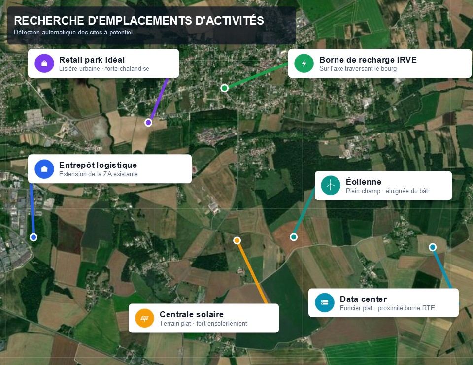
A solid land shortlist takes an analyst weeks. DataScoot delivers it in 48 hours max: qualified sites, explained criteria, verified regulations, false positives eliminated. Warehouses, data centres, EV charging, solar.

94M land parcels. Custom filtering criteria
Implementation site search

Implementation site search

Logistics warehouse · Lille – Cambrai – Arras corridor

81 000
Universe analyzedCadastral parcels on the corridor
388
Raw candidatesAutomatic location detection
121
After cleanupFalse positives excluded · −267 discarded
45
High scoreRetained for review · −76
8
Actionable sitesActionable on the ground · −37
8 actionable sites out of 81,000 parcels · selection rate ≈ 0.01%

Use cases

Four angles, one tool.

Whether you're looking for land, assets to develop, or a regulatory overview, DataScoot adapts its engine to your question.

Common foundation · cross-cutting

Every insight starts with a parcel. Every insight ends with a decision.

DataScoot starts by gathering, on each candidate parcel, all multi-source regulatory constraints: zoning, easements, climate risks, technical compatibility, competitive environment and local socio-economic flows. This common foundation produces traceable reasoning: retained sites are justified source by source, as are discarded ones. You get verifiable reasoning.

Detailed parcel fileCompetitive landscape mapPotential qualification

The opportunity is there. What's missing are the tools to reveal it before anyone else.

Deliverables

Structured deliverables tailored to your needs.

Every project delivers a structured, exportable output linked to primary sources. Hypotheses are documented and calculations are reproducible.

01

Executive summary + detailed parcel sheets

Executive summary + detailed sheets per parcel with ratios, constraints and fully cited sources.

02

Excel workbook + GeoPackage

Structured workbook (summary, TOP list, full list, methodology) and CSV / GeoPackage files ready to load into your GIS or spreadsheet.

03

Heatmaps & choropleths

Sector-level heatmaps and choropleths to visualise the spatial distribution of opportunities and constraints.

04

Investment committee note

A 2-page note for your investment committee, with a ranked recommendation table.

A study that keeps watching for you

Activate monitoring on your territory: DataScoot watches official sources. As soon as a zoning procedure advances, a new DVF vintage is released, or a zone changes, you are alerted.

Monitoring

For whom

Built for those who assess sites before committing capital.

An upstream institutional qualification layer: it compresses the pre-due-diligence phase from several weeks to a few hours.

Property developers & urban planners

Identify zones compatible with the technical and regulatory constraints of a deployment (renewables, datacenter, EV charging, logistics), at regional or national scale, without mobilizing 6 weeks of a consultancy.

"Which municipalities have the land, regulatory and technical conditions for industrial solar deployment in region X?"

Investment funds & asset developers

Identify developable land, prioritize sites to investigate and know, by the next day, where to launch a diagnostic and who to call first.

"Which sites should we launch a Phase 1 diagnostic on, and who should we contact first?"

Infrastructure operators & developers

Build a defensible acquisition thesis (expected yield, regulatory constraints, sensitivity to downside scenario) before committing capital to a site or portfolio.

"Which sites on corridor X combine HTA connection, available industrial land and no Natura 2000 constraint?"
Built exclusively on official public sources

DVFGéoportail de l'UrbanismeCartofrichesCEREMAGéorisquesINSEECadastredata.gouv.fr

Why DataScoot

Why DataScoot instead of ChatGPT or a web search.

Each tool has its purpose. DataScoot is the only one built to transform public data into an auditable, decision-ready report.

CriterionSpecialized land toolsKelFoncier, Urbanease…LLMs & chatbotsChatGPT, Gemini…DataScoot
Natural language query, no training required✗✓✓
Compiled analysis report, ready to decide(vs dashboard to analyze yourself)✗✗✓
Zero hallucination: every figure sourced✓✗✓
Multi-use coverage(land + renewables, datacenter, EV charging, logistics)✗✗✓
On-demand cross-referencing of heterogeneous sources✗✗✓
Custom multi-criteria scoring & reusable Python code✗✗✓
Structured exportable results (Excel/CSV)✓✓✓
Query & data confidentiality✓✗✓

Proof by example

Test DataScoot on your assets.

We frame a precise question together, then produce a sourced report. You judge DataScoot on a concrete result, on your own territory.

A targeted sample on a scope we define together: a real preview of the deliverable, on your sector.

  • Analysis tailored to your challenge (transfer, ZAN, brownfields, subdivision, risks)
  • Official institutional sources cited throughout
  • Interactive map, scored table & usable Excel file
  • Reusable and auditable Python code included
  • Support: scoping, exchanges during production, debrief meeting

Frequently asked questions

No. It is an upstream qualification layer: it ranks the pool and eliminates dead ends so that you engage your due diligence (soil diagnostic, negotiation, notarial checks) only on the right sites. Reports also flag limitations (weak DVF data on small communes, unlisted local taxes, missing layers).

ChatGPT writes fluently but invents and cannot cite a verifiable source; a search engine returns links for you to sort through yourself. DataScoot produces, from a proprietary index of institutional sources, a complete, sourced and auditable report on your precise question, with visuals, scored tables and reusable code.

The index is continuously updated, with more than 5 million files added each month, and APIs queried live where available. You can activate monitoring to be alerted the moment a new land-transaction vintage, a planning revision or a relevant layer appears on your territory.

Yes. Your queries are never used to train a model. Analyses are private to your organisation, never shared or resold, and the deliverables, including the code, belong to you. French company, data hosted in the EU, GDPR-compliant.

Exclusively official public sources: DVF transactions, Géoportail de l'Urbanisme, Cartofriches, CEREMA, Géorisques (soil shrink, flood risk, ICPE), INSEE, land registry and data.gouv.fr. We qualify, normalise and cross-reference these layers; we do no general-purpose web scraping.

No. The examples illustrate the most common use cases, but DataScoot can address any land, regulatory or site question as long as it rests on official public data. We define the scope together before starting.

No. You ask your question in plain language and receive a finished, ready-to-read report. The Python code is included only so that your technical teams can audit or reuse the analysis if they wish.

Each study is delivered with its methodology, cited sources and the Python code behind the analysis, auditable by your teams and reusable in your stack (notebooks, Snowflake, Databricks…). Scoring assumptions and sensitivity analyses are explicit.

Your next acquisition deserves a sourced report.

Give us your question and your territory: we produce a complete, auditable ranking for your case.